

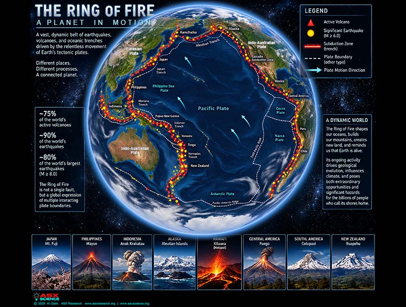
Earthquakes, volcanic eruptions, and tsunamis regularly dominate headlines around the Pacific Ocean. From the Philippines and Indonesia to Japan, Alaska, and the Americas, the region known as the Ring of Fire is responsible for some of the most destructive geological events in recorded history.
But is the entire Pacific becoming more active, or are we simply paying closer attention to a geological system that never stopped moving?
An 18-page ASX Research study published September 9, 2026, examines the forces shaping the Pacific Ring of Fire, the dangers confronting coastal populations, and the technology transforming how scientists observe the planet.
Not One Ring, but Many Moving Boundaries
Despite its familiar horseshoe shape on maps, the Ring of Fire is not a single fault, volcanic system, or interconnected geological structure.
It is a vast collection of interacting tectonic plate boundaries surrounding the Pacific basin, extending through the Americas, Alaska, Japan, the Philippines, Indonesia, and the southwest Pacific.
Its defining process is subduction: the descent of dense oceanic crust beneath another tectonic plate. That motion can produce enormous earthquakes, deep ocean trenches, and chains of active volcanoes.
The same tectonic machinery responsible for catastrophic destruction also builds mountains, creates islands, and recycles material into Earth’s interior.
Why Earthquakes and Volcanoes Occur Together
Where tectonic plates converge, sections of the boundary may remain locked while the plates continue moving. Strain accumulates over decades or centuries until the fault ruptures, sometimes producing a devastating megathrust earthquake.
Meanwhile, water released from the descending oceanic plate contributes to magma formation beneath the overriding plate. That magma can eventually rise to feed volcanic arcs.
This explains why powerful earthquakes and explosive volcanoes frequently occupy neighboring regions, although individual earthquakes and eruptions do not necessarily trigger one another.
Hawaiian volcanoes provide an important exception. Kīlauea is primarily associated with intraplate hotspot volcanism, not the subduction processes that dominate much of the Ring of Fire.
The Philippines: A Geological Crossroads
Few places illustrate the Ring of Fire’s complexity more clearly than the Philippines.
The archipelago occupies an intricate tectonic region where opposing subduction systems, major faults, oceanic trenches, and colliding crustal fragments interact.
The Philippine Fault Zone and surrounding trenches accommodate substantial deformation, making earthquake and volcanic hazards highly variable across the country.
The ASX Research paper examines a reported magnitude 7.8 offshore Sarangani earthquake on June 8, 2026, as a case study in how geological hazards become human disasters through exposure, vulnerable infrastructure, and limitations in preparedness.
The broader lesson is that earthquake magnitude alone cannot describe the danger facing a community. Construction quality, terrain, coastal geography, and emergency response can determine whether an event becomes a catastrophe.
Indonesia and the Power of Volcanic Systems
Indonesia occupies another exceptionally complex tectonic environment, with more than one hundred active volcanoes distributed across multiple volcanic arcs.
The September 2026 research discusses reported unrest at Anak Krakatau and the aviation disruptions associated with volcanic activity.
Volcanic ash can threaten aircraft engines, visibility, airport operations, and international transportation networks. Even eruptions far from major cities can produce economic consequences across national borders.
But simultaneous activity at several Indonesian volcanoes does not establish that the volcanoes are operating as a single synchronized system.
When the Seafloor Moves, the Ocean Responds
Some of the Ring of Fire’s greatest dangers begin beneath the ocean.
Large subduction earthquakes can displace enormous sections of the seafloor, transferring energy into the water above and generating tsunamis capable of crossing entire ocean basins.
The 2004 Sumatra–Andaman earthquake and Indian Ocean tsunami demonstrated the catastrophic consequences of this process, killing approximately 230,000 people and displacing roughly 1.7 million.
Tsunami severity depends on much more than earthquake magnitude. Fault geometry, rupture depth, vertical seafloor displacement, ocean depth, and coastal configuration all influence the resulting waves.
From Japan and Alaska to Chile
The Pacific’s northern and eastern margins contain some of Earth’s most consequential earthquake zones.
Japan experienced the devastating magnitude 9-class Tōhoku earthquake and tsunami in 2011. The Alaska–Aleutian system contains extensive subduction boundaries, while Cascadia presents a major earthquake and tsunami hazard along the northwestern coast of North America.
Farther south, the Nazca Plate descends beneath South America, producing the Andes and some of the largest earthquakes ever recorded.
The 1960 Chile earthquake, approximately magnitude 9.5, remains the largest instrumentally recorded earthquake.
These regions share fundamental tectonic processes but differ significantly in fault geometry, volcanic behavior, and earthquake recurrence.
Is the Ring of Fire Waking Up?
The study challenges the popular impression that several frightening geological events appearing in the same news cycle prove that the entire Pacific is entering a new period of instability.
Large earthquakes can influence stresses on nearby faults, and some volcanic systems may respond to regional seismic activity under particular conditions. However, temporal coincidence is not proof of a Pacific-wide chain reaction.
Plate boundaries are segmented, volcanic reservoirs behave differently, and many geological processes operate independently.
A sudden increase in headlines is not necessarily an increase in planetary activity.
Why the Human Danger May Be Increasing
Even without an accelerating geological system, the consequences of earthquakes and eruptions can become more severe.
Coastal populations are expanding. Airports, ports, power networks, communications systems, and supply chains increasingly occupy regions exposed to geological hazards.
An eruption that once affected a small settlement may now interrupt international aviation and transportation across multiple countries.
The research distinguishes between geological hazard and disaster risk: Earth supplies the physical process, while human exposure and vulnerability determine much of its impact.
Can Scientists Predict the Next Disaster?
Scientists cannot currently predict the exact time, location, and magnitude of a major earthquake with reliable deterministic precision.
Earthquake early-warning systems perform a different function. They detect a rupture after it begins and may provide seconds or tens of seconds of warning before strong shaking reaches more distant locations.
Volcanic forecasting uses seismic activity, ground deformation, gas emissions, thermal measurements, and other indicators to assess unrest. These observations improve hazard assessments but cannot guarantee whether or when an eruption will occur.
Satellite radar, GNSS, ocean-bottom sensors, offshore pressure instruments, and increasingly dense monitoring networks are transforming the scientific picture.
Artificial Intelligence and the Future of Hazard Monitoring
Artificial intelligence may become an increasingly important tool in earthquake and volcanic science.
Machine-learning systems can analyze large seismic catalogs, detect subtle patterns in volcanic tremor, process satellite imagery, and combine observations from thousands of instruments.
Yet the study emphasizes an essential distinction: recognizing patterns is not the same as establishing physical causation, and an algorithm’s confidence does not guarantee that its conclusions are correct.
The future lies in combining advanced instrumentation, physical models, human expertise, and rapid information sharing to improve warning and response.
The Planet Never Went to Sleep
The Ring of Fire will continue producing earthquakes, eruptions, tsunamis, and tectonic deformation for geological timescales.
There is no compelling evidence in the research that the entire Pacific margin is accelerating toward a synchronized catastrophic phase.
What is changing is humanity’s ability to observe these processes and reduce their consequences through resilient infrastructure, monitoring, evacuation planning, and public education.
The study concludes with a distinction worth remembering: the Ring of Fire is not waking up. It never went to sleep. What is changing is humanity’s ability to watch it breathe.
Read the complete 18-page ASX Research paper: The Ring of Fire: A Planet in Motion — Tectonic Power, Cascading Hazards, and the Future of the Pacific Margin — ASX Research Journal and Database, September 9, 2026.