


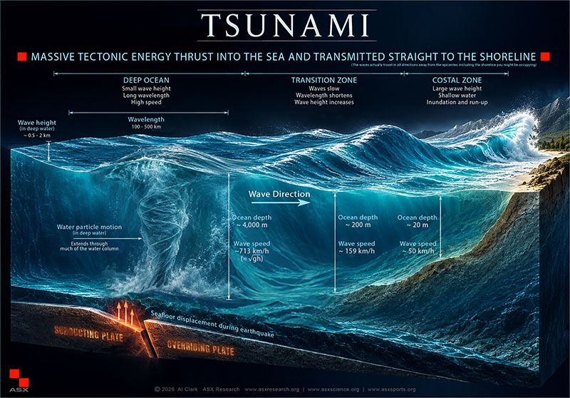
The ocean does not need a storm to become deadly. A major earthquake, collapsing volcano, or underwater landslide can displace an enormous volume of seawater, setting in motion waves capable of crossing entire oceans and devastating coastlines thousands of kilometers away.
In a 22-page ASX Research study, aviation safety researcher Albert N. Clark examines the physics behind tsunamis, the disasters that transformed scientific understanding, and why even sophisticated warning systems cannot guarantee that coastal communities will have enough time to escape.
How a Tsunami Begins
Most destructive tsunamis originate from powerful submarine earthquakes, particularly where one tectonic plate moves beneath another. Sudden deformation of the seafloor displaces the water above it, creating long-period gravity waves that spread outward from the disturbance.
Unlike ordinary wind-driven waves, tsunami motion can involve much of the water column. Their wavelengths may extend hundreds of kilometers, allowing them to travel rapidly through deep water while remaining relatively inconspicuous at the surface.
In an ocean approximately 4,000 meters deep, a tsunami can travel at roughly 713 kilometers per hour—comparable to the cruising speed of a commercial aircraft.
Why the Coastline Changes Everything
As a tsunami approaches shallower water, its speed decreases and its wavelength contracts. Depending on the seabed and coastal geography, the water may rise dramatically, form a turbulent surge, or advance inland as a rapidly growing flood.
Two measurements are particularly important. Run-up describes the maximum vertical elevation reached by the water, while inundation distance describes how far the flooding extends inland. A steep shoreline may experience extraordinary run-up, while a relatively flat coastal plain may suffer flooding across a much greater distance.
The first arriving wave is not necessarily the largest. Reflections and subsequent waves can prolong dangerous conditions, making an apparently calm shoreline deceptive.
Disasters That Changed Tsunami Science
The study examines major events spanning nearly three centuries, beginning with the devastating 1755 Lisbon earthquake and tsunami and the catastrophic 1883 eruption of Krakatau.
In 1958, a massive landslide into Alaska’s Lituya Bay drove water approximately 524 meters up a nearby slope. That extraordinary figure describes localized run-up—not the height of a wave traveling across the open ocean.
The 1960 Chilean earthquake, the largest instrumentally recorded at magnitude 9.5, generated a tsunami that crossed the Pacific, causing deaths in Hawaii and Japan and reaching the Philippines.
On December 26, 2004, the Indian Ocean tsunami killed approximately 230,000 people, with estimates varying. The disaster exposed critical weaknesses in warning infrastructure and public awareness across multiple countries.
Japan’s 2011 Tōhoku earthquake and tsunami demonstrated that advanced monitoring, coastal defenses, and evacuation infrastructure can still be overwhelmed. Flooding also disabled essential systems at the Fukushima Daiichi nuclear facility, creating a cascading technological disaster.
Not Every Tsunami Begins With an Earthquake
The 2018 Anak Krakatau tsunami resulted from a volcanic flank collapse, producing destructive waves without the conventional warning signals associated with a great megathrust earthquake.
In January 2022, the Hunga Tonga–Hunga Haʻapai eruption demonstrated another mechanism: atmospheric disturbances generated by the eruption contributed to tsunami signals observed around the world, alongside direct volcanic effects on the ocean.
These events reveal an important limitation. Warning networks designed primarily to detect earthquakes may provide inadequate notice when a tsunami originates from a rapidly developing volcanic collapse or another nonseismic disturbance.
The Philippines and the Warning-Time Problem
The Philippines faces tsunami hazards associated with multiple offshore geological systems, including the Manila Trench and Philippine Trench. Exposure varies considerably between coastlines, depending on the location of the initiating disturbance, underwater terrain, and local geography.
A distant earthquake may allow hours for warnings and evacuation. A nearby event may leave only minutes.
Modern warning systems combine seismic monitoring, deep-ocean pressure sensors, tide gauges, and computer models. But their effectiveness ultimately depends on how quickly information reaches threatened communities and whether residents know how to respond.
Strong or prolonged earthquake shaking near the coast can itself be a natural warning. Waiting for an official announcement may consume the limited time available to reach higher ground.
What the Research Ultimately Reveals
Rising sea levels may increase tsunami inundation in vulnerable coastal areas without changing the underlying probability of a major earthquake. Meanwhile, growing coastal development places additional people, transportation networks, hospitals, and essential infrastructure in potentially exposed locations.
The study concludes that scientific forecasting must be matched by practical preparedness: credible local hazard maps, accessible evacuation routes, effective public communication, and an understanding that protective structures cannot eliminate every risk.
A tsunami may begin with a geological disturbance that nobody onshore can see. The difference between survival and catastrophe often depends on recognizing the danger and acting before the water arrives.
Read the complete 22-page ASX Research paper: The Science and Mechanics of a Tsunami — ASX Research Journal and Database, September 21, 2026.